Welcome
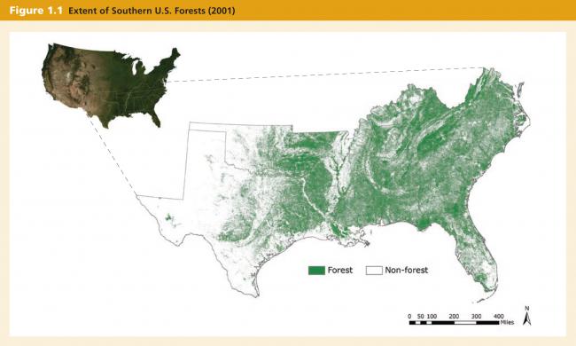
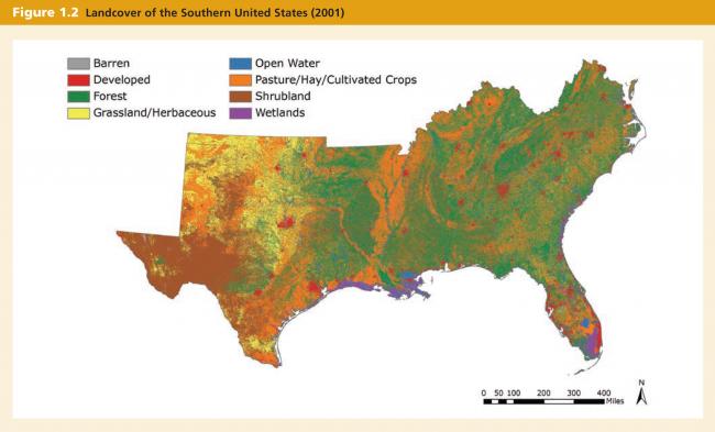
The forests of the southern United States are a vast local, national, and global treasure. Spanning approximately 214 million acres1, they stretch from Texas to Virginia and from Kentucky to Florida (Figure 1.1). They comprise 40 percent of the land area of the 13 states that constitute the U.S. Forest Service’s “southern region,” and 29 percent of the total forestland in the United States.2 They are the dominant form of land cover throughout the region (Figure 1.2).
 Source: Satellite imagery (ESRI 2008; ESRI, i-cubed, and GeoEye 2009), forest cover (U.S. Geological Survey 2007), administrative boundaries (ESRI Data and Maps 9.3.1, ESRI 2008).
 Source: Landcover (U.S. Geological Survey 2007), administrative boundaries (ESRI Data and Maps 9.3.1, ESRI 2008).
-
Smith, W. Brad, Miles, Patrick D., Perry, Charles H., and Pugh, Scott A. et al. 2009. Forest Resources of the United States, 2007. Gen. Tech. Rep. WO-78. Washington, DC: U.S. Department of Agriculture, Forest Service. ↩
-
Conner, Roger C., and Andrew J. Hartsell. 2002. “Forest Area and Conditions.” In Wear, David N., and John G, Greis, eds. Southern Forest Resource Assessment (2002). Gen. Tech. Rep. SRS-53. Asheville, NC: U.S. Department of Agriculture, Forest Service, Southern Research Station. ↩


